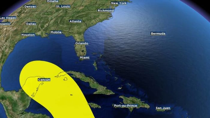
ORLANDO, Fla. – Don’t look now, but as Helene headed toward Florida as a major hurricane, the National Hurricane Center on Thursday marked an area in the western Caribbean as a spot to watch for possible future tropical development.
Hurricane officials said an area of low pressure could form over the western Caribbean by the middle of next week.
[RELATED: CONE, MODELS | COUNTY-BY-COUNTY | TIMELINE | RADAR | DOWNLOAD: Free hurricane app]
“Environmental conditions are expected to be conducive for slow development thereafter, while the system moves generally northwestward,” the NHC said.
As of Friday morning, the NHC said there’s a 30% chance of tropical development over the next seven days.
Since the low pressure system has not yet formed, it’s too soon to know many details, including how strong the possible system could become or where it may head — if it forms.
Helene lashed Florida as an “extremely dangerous” Category 4 hurricane, bringing “catastrophic” storm surge in northwestern parts of Florida as well as damaging winds, rains and flash floods hundreds of miles inland across much of the southeastern U.S., forecasters said.
The governors of Florida, Georgia, the Carolinas and Virginia have all declared emergencies in their states.
Get tropical weather updates from Jonathan Kegges sent right to your inbox.


Post comments (0)